
When a real estate property is identified to be within a natural disaster event, ValINSPECT DisasterTM is employed to assess properties for potential damages post-disaster by collecting photos and data.
Two Inspection Types Available
Inspections are conducted through either in-person inspections or virtual inspections conducted via real-time, live-streaming video connections with an onsite homeowner or other contact. Virtual option may be done on demand during business hours or scheduled.
Virtual Inspection
Valligent provides a seamless connection to homeowners or on-site contacts through a live video stream. A convenient option when only the homeowner has access to the property. During the video stream the virtual inspector captures photos of the exterior and neighborhood, then fills out a comprehensive form detailing the condition, all without the need for a third party to travel to the affected area.
This process typically takes around one business day to complete once access to the property is granted.
In-Person Inspection
Valligent appoints a trained local real estate broker or agent to conduct an exterior inspection of the subject property and capture photos of both the property and its surroundings. Subsequently, they fill out a comprehensive form documenting the condition of the property to deliver to the client.
This process typically takes about two business days to complete once access to the property is granted.
Trained inspectors deliver detailed assessments of the property’s current state, categorizing damages as non-existent to major, thereby equipping users with actionable information for informed decision-making. Reports are especially useful to mortgage originators and servicers, offering valuable insights for pre-funding evaluations or portfolio management.
In a survey of over 1,400 users, 97% reported satisfaction with their virtual inspection experience, 98% of users said inspectors communicated clearly and effectively, and 98% found the inspection easy.
Add Veros’ Disaster Vision to Prioritize Inspections
By combining the extensive property-level data from Disaster Vision (by Veros Real Estate Solutions- Veros®) with ValINSPECT Disaster, lenders can effectively identify and prioritize inspections for properties at higher risk of natural disaster impact. This eliminates the need to inspect every property within FEMA-declared counties immediately.
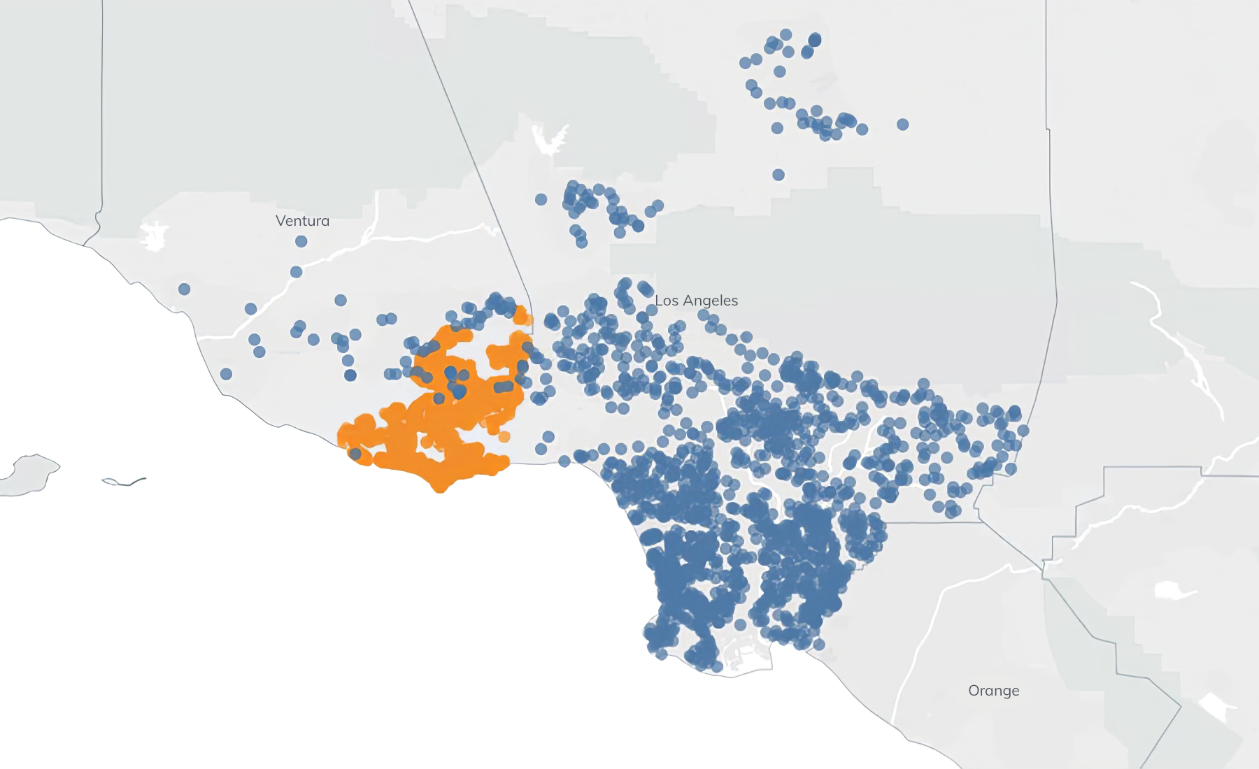
Disaster Vision leverages satellite imagery, drone imagery, federal/state agency reports, weather data, NASA burn points, and FEMA data to assess a natural disaster’s impact. From individual property lookups to portfolio monitoring, it offers versatile solutions for mortgage lenders, servicers, and insurance firms.
(Left Image: Woolsey fire. Blue dots were in the FEMA declared zone. However, the only properties potentially impacted were in the orange zone.)
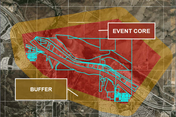
Disaster Vision evaluates potential impact of a natural disaster at the property level by harnessing geospatial data to identify a central disaster zone and its surrounding buffer area. Using a nationwide geo-coded property database, Disaster Vision goes beyond county-level FEMA declarations, delivering accurate insights into potentially impacted properties.
Disaster Vision + ValINSPECT Disaster Equip Users to:
Know which subject properties to focus inspection on first.
Understand the extent of subject property damage.
Obtain the data needed to start estimating repair expenses.
Speak With Our Team
877-490-0390